
Why Australia and New Zealand Are Farther Apart Than They Appear
The Australia-New Zealand distance is a good reminder that political and cultural closeness does not necessarily mean geographical closeness. The two countries have built exceptionally strong connections across the Tasman Sea, but their actual landmasses are separated by a substantial stretch of ocean. The figure becomes even more complicated when Tasmania and Australia’s numerous islands and offshore territories are considered. Official Australian geographic data confirms that Australia’s territory extends well beyond its mainland, making precise distance comparisons dependent on the locations and boundaries being used.
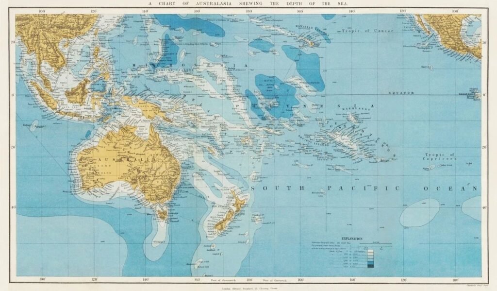
Australia and New Zealand are often described as close neighbors because they share strong cultural, economic and political ties. Yet their geographical separation is surprisingly large. The two countries sit across the Tasman Sea, with a vast stretch of ocean between their nearest major land areas.
A widely shared geographic comparison highlights just how substantial this separation is. It uses the northwestern tip of New Zealand and the nearest point on Australia as reference locations, demonstrating that the two countries are separated by a distance that is far greater than many people might assume when looking at a conventional world map.
A Large Ocean Gap Between Two Close Partners
Australia and New Zealand are located in the southwestern Pacific, but neither country is positioned immediately beside the other.
Australia stretches thousands of kilometres from north to south. Its southernmost point is South East Cape in Tasmania, while its eastern coastline reaches toward the Pacific.
New Zealand, meanwhile, consists primarily of two large islands and several smaller islands located east of Australia.
The result is a substantial expanse of ocean separating the two countries.
This distance is one reason why flights between Australia and New Zealand can take several hours despite the countries being frequent travel partners.
The Tasman Sea Creates the Separation
The body of water between Australia and New Zealand is known as the Tasman Sea.
It is an important part of the southwestern Pacific and has historically influenced travel, shipping and communications between the two countries.
Modern aircraft have made the journey relatively easy, but the physical geography remains striking: Australia and New Zealand are separated by open ocean rather than a chain of closely spaced islands.
Why Maps Can Be Misleading
The apparent distance between countries can change significantly depending on the type of map being used.
A flat world map compresses or distorts geographical relationships because the Earth is spherical. The effect becomes especially noticeable when comparing locations across large distances.
Australia itself is enormous. Geoscience Australia estimates that the continent extends almost 4,000 kilometres from east to west and about 3,860 kilometres from its northernmost point to its southernmost point in Tasmania.
Consequently, the distance from New Zealand to Australia depends heavily on which points in the two countries are being compared.
Tasmania Changes the Picture
Tasmania is particularly important when discussing Australia’s geographical relationship with New Zealand.
The island state lies south of mainland Australia and has its own extensive coastline. Geoscience Australia records Tasmania’s total coastline at about 4,872 kilometres when both mainland Tasmania and its islands are included.
If Australia’s islands and territories are included in a geographical comparison, the answer to “how far is Australia from New Zealand?” can therefore become more complicated.
The closest Australian land is not necessarily the closest point on the Australian mainland.
Australia Is More Than Its Mainland
Another reason geographic comparisons can be confusing is that Australia has numerous islands and offshore territories.
Geoscience Australia lists thousands of Australian islands, including major islands associated with Queensland, Tasmania and other jurisdictions.
Australia’s territorial reach also extends far beyond the mainland into the Pacific, Indian and Southern oceans.
This means that the precise answer to a distance question depends on whether the comparison considers only the Australian mainland or Australia’s broader territory.
Strong Connections Despite the Distance
The geographical separation has not prevented Australia and New Zealand from developing exceptionally close relationships.
The two countries cooperate extensively in areas including trade, defence, migration, science, disaster response and regional security.
Their geographical proximity relative to many other international partners has also encouraged frequent movement of people and goods across the Tasman Sea.
Air travel has made the distance feel much smaller in everyday life than it would have appeared to earlier generations.
A Major Aviation Route
The Australia-New Zealand corridor is one of the most heavily travelled international routes in the South Pacific.
Large numbers of passengers travel between cities such as Sydney, Melbourne, Brisbane, Auckland and Wellington.
Although the countries are separated by open ocean, modern aviation effectively transforms the geographical barrier into a manageable journey.
For travellers, the distance can therefore seem surprisingly short compared with the scale of the Pacific Ocean.
Geography Also Matters for Maritime Boundaries
The ocean separating Australia and New Zealand is not simply empty space.
The two countries have negotiated maritime boundaries covering areas of their exclusive economic zones and continental shelves. Geoscience Australia’s official geographic information includes treaty-defined boundaries between the two countries.
These boundaries matter for fisheries, seabed resources, navigation and the legal management of surrounding waters.
Thus, the distance between Australia and New Zealand has both geographical and economic significance.
The Southern Pacific Connection
Australia and New Zealand also occupy strategically important positions in the wider Pacific region.
Their locations provide access to major maritime routes linking the Indian and Pacific oceans.
Both countries are involved in regional cooperation with Pacific island nations, making their geography relevant not only to bilateral relations but also to wider regional security and economic affairs.
The Distance Is Easy to Underestimate
The biggest surprise is psychological.
Australia and New Zealand are frequently discussed together, share many cultural similarities and have extremely close political relations. On a simplified map, this can create the impression that they are almost next-door neighbors.
Geographically, however, there is a significant oceanic gap between them.
The exact distance changes according to the points selected, which is why a single number should not be treated as universally applicable.